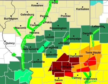
A number of severe weather events impacted parts of central and eastern Illinois in two rounds on Sunday, including at least one observed tornado, flash flooding, and severe thunderstorms.
The National Weather Service issued tornado warnings for portions of Effingham and Shelby Counties at around 3:18 and 3:23 p.m., respectively. The threat moved eastward, subsequently affecting the counties in that direction. The National Weather Service reported staff at the Flora Police Department witnessed a tornado to the north within the warning area. Other warnings came from radar-indicated threats.
Then at 7:29 p.m., Christian County was the setting for a tornado warning as a system progressed through Edinburg and eastward. Shelby County received the warning shortly thereafter as spin-up threats emerged. The warning zone shifted towards the east, but Clarksburg and Strasburg were added again to the zone when tornado potential re-emerged. Much of Shelby County also saw heavy rains. The tornado warning expired at 9:15 p.m.
Severe thunderstorm warnings were issued for Shelby and Effingham Counties in the afternoon spell, while the entirety of the latter county saw flash flood warnings as well. These warnings were part of a wider system of precipitation which hit much of central and northern Illinois, as well as eastern Iowa and southern Wisconsin. It continued into much of Indiana and portions of Michigan and Ohio.
The National Weather Service will provide a full report of confirmed tornadoes and other details on the severe weather in the coming days. Stay tuned to TaylorvilleDailyNews.com for more information and updates regarding the storms.