

The U.S. Army Corps of Engineers has provided the latest water level update from Lake Shelbyville.
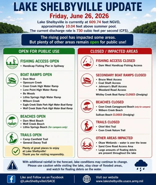
The lake level is currently at 609.74 feet National Geodetic Vertical Datum (NGVD). NGVD is the baseline water level used to determine flooding. At this time, the NGVD is approximately 10.04 feet above the summer pool level. The current discharge rate is listed at 730 cubic feet per second. Officials say the rising pool has impacted some areas around the lake, but plenty of locations remain open for public use.
Several fishing access points, beaches, and trails are closed, including the Dam West Handicapped Fishing Access. Some of the beaches and trails that remain closed include Coal Creek Beach, Wilborn Creek Beach, and the Chief Illini Trail. Some secondary boat ramps and shoreline areas have also been impacted.
Open areas include several fishing access points, boat ramps, beaches, and trails, giving visitors options to continue enjoying the lake. Officials are reminding visitors that conditions may continue to change with additional rainfall in the forecast. Those using the lake are encouraged to use caution, avoid closed areas, and watch for floating debris on the water.
See the picture below for a full list of closures and for what is still open at the lake.

Get all your local news, weather, sports, and more at taylorvilledailynews.com.


